Pages

Friday 16 October 2015

We have moved!


The Suburban Newspaper has a new website with real time news and information. 
You can now follow The Suburban Weather Page at this link.

Wednesday 14 October 2015

Coldest air of the season this weekend - snow?

The coldest air of the season to date will pour into southern Quebec and Ontario this weekend.
Snow this weekend? There are hints of the four letter word creeping into the forecast. Don't panic just yet. Cold air will pour into Ontario and Quebec behind a cold front late Friday. Temperatures will fall to near 0C (32F) by Saturday morning, and even colder -2C (28F) by Sunday here in Montreal. It will be much colder north of the city in the Laurentians, dropping to as cold as -10C (14F). I expect a widespread frost and freeze bringing the growing season or what is left of it to an end.

Snow
As far as any snowfall goes, there will be moisture available behind the front Friday, but it will be fairly limited in the valleys with perhaps a flake or two in Montreal. However, if you are travelling northwest of Montreal towards Val-d'or, where it is snowing this morning, or south across the Adirondacks of New York or Green Mountains of Vermont, there could be quite a bit more. Computer models are hinting at perhaps 5-10cm (2-4 inches) of new snow by Sunday morning across areas above 1500 feet. Even 15cm (6 inches) is forecast at Jay Peak. If you are taking Interstate 89 or 87 south, you may encounter snowfall Saturday night. Be aware of this.

It will turn warmer next week after the brief cold spell. However, you should be thinking about winter tires. It looks like there could be several opportunities for an early season snow in November over southern Quebec. Just a heads up.

Tuesday 13 October 2015

Colder weather with frost this week for Montreal

It was a perfect Thanksgiving Monday on L'Ile Perrot with sunshine and record warmth. (ValleyWX Photo)
Depending on where you were in southern Quebec on Thanksgiving Monday, you may have had the warmest October 12 on record. The temperature reached 24.9C (77F) here on L'Ile Perrot but 23.5C (75F) at Trudeau Airport just missing the record of 23.9C (76F) set in 1961. No matter where you were across the region it was a perfect way to end the summer season for good. I say that because much colder air is on the way. Looking ahead I don't see another opportunity for temperatures that warm. We are rapidly loosing daylight as well which tends to limit just how warm it can get.

Frost & Snowflakes
This morning a series of cold fronts is off to our west and will begin the slow process of lowering temperatures this week. Expect showers to develop today and persist into Wednesday. The temperature will reach 18C (65F) today, but only 12C (54F) Wednesday and no better than 5C (41F) by Saturday. The weather will be rather unsettled all week with limited sunshine and periodic showers. I am quite confident that by Saturday or Sunday morning we will see a hard frost in most regions of southern Quebec including metro Montreal. Overnight lows will drop below freezing for the first time this season. There is also the chance for a few snow showers across the mountains of southern Quebec and New England. Looking ahead into next week milder temperatures are forecast to return but not the 20 plus weather we just experienced.

Monday 12 October 2015

Warm Thanksgiving for Montreal then turning much colder

The warm Thanksgiving in Montreal will be replaced by much cooler air, clouds and showers as the weeks moves along.
It will be an Indian Summer type day across southern Quebec, Ontario and New England on this Thanksgiving Monday. Temperatures will be on the rise aided by gusty southwest winds up to 50km/h and sunshine. Expect warm highs of 21C to 24C (70 to 75F) across the region, well above the normal high for Montreal of 13C (55F). The brief warmth is being caused by strong low pressure moving out of the Prairies and across the Great Lakes. Montreal has an outside shot today at the record high of 23.9C (76F) set in 1961.

This system has a strong cold front associated with it that is plunging temperatures back to reality behind it. Over the weekend warm air rushed north ahead of the system pushing temperatures to record levels across the west. It was downright hot in the northern US plains states with Fargo, North Dakota reaching 97F (36C) smashing a 72 year old record of 85F from 1973. Temperatures pushed into the middle to upper 20's across southern Manitoba and Saskatchewan before the front arrived. The front arrived with strong to severe winds sweeping across the region. Gusts were reported to 109km/h at Leader and 104km/h at Assiniboia in Saskatchewan. In Alberta a gust to 111km/h occurred at Alliance and 89km/h in Edmonton.

In Montreal the sunshine of today will be replaced by clouds and showers for the rest of the week. After the warm temperatures today, we will see gradual decline in highs and lows through next weekend. By Saturday the high will only be 6C (43F) in Montreal with lows near freezing and frost expected. We may even see the first snowflakes of the season across the mountains of New York, Vermont, the Laurentians and Townships by late Friday night.

Wednesday 7 October 2015

Epic flooding in the Carolinas - rain on the way for Montreal

The weather has been rather quiet in Montreal with partly cloudy skies and seasonable temperatures. A large area of high pressure over central Quebec has deflected any storm activity well to our south and east including hurricane Joaquin. Sunshine will prevail again on Thursday with temperatures a little cooler than they have been of late. There is even a risk of frost away from the St. Lawrence Valley, particularly across the lower Laurentians. The low is expected to be near 2C (36F) with highs around 13C (55F). Our extended period of dry weather will end Friday as low pressure moves into the region with widespread rain. At this time it looks like 15-25mm of rain will fall through Friday evening. Skies will clear out for the weekend with temperatures near normal.

Historic flooding from last weekend in South Carolina. (Charleston Post Courier Photo)
The clean up continues in South Carolina after epic rainfall last weekend. Some locations recorded 1000 year rain events with as much as 27 inches (over 685mm) of rain in less than 5 days. That amounts to nearly an entire years worth of rainfall here in Montreal where the annual average is 784mm. The rain destroyed homes and washed away roads including a portion of Interstate 95 as well as infrastructure, claiming at least 17 lives. Flooding was also reported in North Carolina and in coastal communities from Georgia to Maine. The heavy surf and coastal flooding was caused in part by hurricane Joaquin passing well offshore. The heavy rain was the result of an upper level low over the southeast US and a persistent ribbon of moisture moving inland from the tropical Atlantic. Many rivers remain above flood stage with more damage expected in the coming days. Evacuations have been ordered in many areas with as many as 13 dams failing so far in South Carolina. Damage is expected to be in the billions of dollars.

While Montreal has had no rain so far in October, portions of the east coast were inundated.

Saturday 3 October 2015

Hurricane Joaquin moves out to sea - high pressure dominates in Montreal

Coastal flooding in Atlantic City, New Jersey on Friday. (Reuters News)
What a difference 24 hours can make in weather forecasting. Computer models had communities up and down the east coast from South Carolina to Nova Scotia in a state of emergency at the prospect of a land falling Joaquin. But now all models are predicting the storm to head out to sea and spare all of us a direct hit. Hurricane Joaquin remains a powerful storm this morning with 125 mph winds located 165 miles (270km) northeast of San Salvador, Bahamas. The storm pounded the northeast Bahamas for the last two days with fierce winds and heavy rain. Damage is extensive in the eastern portion of the Bahamas.

Meanwhile the news is not perfect for the east coast of the US. They are still dealing with a major upper level low over the southeast that is producing historic rainfall. Up to 2 feet of rain has fallen along the North and South Carolina border with more forecast. The rain has produced major flooding in the Carolinas. Along the coast high surf has produced widespread coastal flooding from Massachusetts to North Carolina. The heavy surf is a result of the flow of air around Joaquin and a persistent northeast fetch of air and water off the Atlantic. Strong high pressure located over Quebec is helping deflect Joaquin out to sea but is also producing the pressure gradient that is driving the Atlantic into the coast from the Maritimes south. Flooding is expected to continue throughout the weekend.

MONTREAL
The good news for Montreal is the only effects we will see from both Joaquin and the strong low over the southeast is a cool northeast wind up to 50km/h. Montreal and most of southern Quebec can expect nothing but sunshine as high pressure holds all weekend. Temperatures will range from 12 to 14C (52 to 56F) for daytime highs and cool plus 3 to 5C (38 to 41F) for overnight lows through Monday.

Thursday 1 October 2015

Joaquin now a major hurricane

A NOAA satellite image of a strengthening hurricane Joaquin in the central Bahamas early Thursday morning. 
It has been a rather quiet Atlantic hurricane season to this point, as is typical during El Nino years. But as forecasters always remind us, all it takes is one storm to make the season memorable or infamous. Will Joaquin be that storm? In less than 24 hours the system has gone from a tropical storm to a major hurricane. The Category 3 storm with winds in excess of 120 mph is drifting southwest in the central Bahamas this morning. The Bahamas will have strong winds, pounding waves and torrential rain for the next 24 hours. Joaquin is a small but dangerous storm for that region today with life threatening wind and rain. Beyond that the storm is forecast to move northward and increase in forward speed through Friday. Interests all up and down the east coast should be monitoring Joaquin. At this time computer models have the storm track all over the place from out to sea to landfall along the Outer Banks of North Carolina. An average forecast path takes the storm into the waterlogged middle Atlantic and eventually into New England and southern Quebec by Tuesday. That scenario is far away and Joaquin has several chapters to write before that point. I have been tracking Atlantic hurricanes since 1979 and will watch this one closely and update the blog as needed.

Before Joaquin arrives on the weather scene, Montreal is looking at much cooler air to start October but with plenty of sunshine. Temperatures are expected to be near the freezing point at night and into the low teens for highs through Saturday.

Wednesday 30 September 2015

Major east coast rain event as Joaquin forms in Atlantic

A poorly timed cold front produced heavy rain and snarled traffic during the Tuesday evening commute in Montreal. (ValleyWX)
 Tuesday was very warm across southern Quebec, perhaps the last really muggy day of 2015. Temperatures reached 25C (77F) in Montreal, well above the normal high of 17C (63F). A cold front plowed into the St. Lawrence Valley during the evening commute with very heavy rain. Nearly 20mm fell in less than one hour in Montreal, with 35mm as of 7am this morning. As much as 51mm fell in Kemptville, Ontario with the frontal passage. Light rain continues in Montreal this morning, but the heavy rain has settled south along the US border and into New England. The front has stalled over those regions and is acting like a conveyor transporting copious amounts of tropical moisture into the northeast. Rainfall may exceed 100mm (4 inches) from Pennsylvania and New York into southern New England and the Maritimes. Numerous flood watches and warnings are on place including heavy rain warnings for the Eastern Townships. High pressure will slowly clear out southern Quebec over the next 24 hours, but it will be much cooler along with stiff northwest winds up to 50km/h. Low temperatures in Montreal will drop to 5C (41F) with highs around 14C (56F).

The current NHC forecast track for Joaquin.
Tropical Storm Joaquin
Another major player in the flood potential shaping up along the east coast will be the future track of tropical storm Joaquin. The storm developed in the Atlantic this week and is located 240 miles east northeast of the Bahamas this morning. Joaquin has 70 mph winds but is strengthening and will likely reach hurricane status today. Joaquin is expected to drift west southwest over the next 24 hours before moving north. The storm may impact portions of the eastern US and Canada beginning as early as Sunday with torrential rain. One forecast model has the storm approaching northern New England and southern Quebec by late Monday. Another has it remaining over the Atlantic. This storm will have to be monitored very closely, especially for coastal regions from North Carolina to Nova Scotia. The National Hurricane Center forecast models have Joaquin reaching Category 2 strength with winds in excess of 100mph. With most of the area from the middle Atlantic north being saturated with the current rain event, the potential for major flooding is very real.

Monday 28 September 2015

A more fall-like weather pattern ahead for Montreal

A ship passes under the full harvest moon around 7pm along the St. Lawrence Seaway off L'Ile Perrot. (ValleyWX)
The lunar eclipse begins shortly after 8pm last evening. This photo was taken from L'Ile Perrot. (ValleyWX)
It was a beautiful night to watch the rising of the harvest moon and the total lunar eclipse on Sunday evening. The celestial event, 30 years in the making, did not dissapoint. I went to Pointe-du-Moulin on the tip of L'Ile Perrot and took the photos you see above and below. I was using my old reliable Canon Power Shot 35mm Digital with the zoom maxed out. It was a perfect night, warm temperatures for late September and just a light breeze lapping the waves against the shore, simply stunning.

The lunar eclipse reaches totality just after 10pm last evening. This photo was taken from L'Ile Perrot. (ValleyWX)
 COOLER WEATHER ON TAP
After what was basically an extension of summer during the month of September in Montreal, we are looking at a more seasonable weather pattern over the next few days. Monday and Tuesday will be cloudy with scattered showers and warm temperatures near 23C (73F). By late Tuesday a cold front will cross the region and tap into moisture moving up the east coast. Expect steady rain to develop by late in the day Tuesday and continue overnight. Amounts may exceed 25mm over Ontario, Quebec and New England. Skies will slowly clear Wednesday but it will turn much cooler with highs only in the middle teens. Temperatures will average below normal to end the week with even a risk of frost on a couple of nights as lows fall into the 2 to 4C (36-40F) range. More rain and cooler weather is possible to end the week. We may have just seen the last of the really warm air until next spring.

Sunday 27 September 2015

Lunar Eclipse weather update for Montreal

NASA.org
Excellent fall weather continues for much of southern Quebec this weekend. Temperatures have trended a touch cooler, especially the overnight lows. We start the morning at a chilly 5C (41F) here on L'Ile Perrot with just a hint of frost on some roof tops. Some rural areas in eastern Ontario and southern Quebec were as low as 1C (33F) with a light ground frost. It will warm rapidly today under a light southerly flow with high temperatures near 24C (76F). This will be the last really warm day for quite some time as cooler weather and showers are forecast this week.

LUNAR ECLIPSE
Tonight is the big super harvest moon (see story below). The largest and closest full moon of the year, will rise in Montreal at 6:36pm. The eclipse will begin around 8:45pm, reaching totality near 10:30pm. The weather looks perfect here in Montreal with clouds remaining to our south and west. Nothing but clear skies are expected, at least until midnight, when clouds will begin to increase. A lunar eclipse is safe to watch so enjoy the show.

Huge waves pound coastal highway 12 in Kitty Hawk, North Carolina. (OBX Voice)
COASTAL STORM
Those clouds are part of a large coastal storm that has been moving up the eastern seaboard. The system has brought heavy rain, high winds and round after round of high tides and coastal flooding from the Carolinas north. The combination of the supermoon and this storm are flooding portions of the Outer Banks of North Carolina. Tides can run as much as 30 percent above normal during a supermoon. Those tides along with the storm are pushing the Atlantic Ocean over the dunes and flooding portions of State Highway 12. Flooding has also been reported in South Carolina and along the coast northward into New Jersey.

Wednesday 23 September 2015

Fall equinox, harvest supermoon plus a lunar eclipse

A stunning photo of the full supermoon from October 2014
What a celestial week it will be across North America. First, fall arrived in the Northern Hemisphere at 4:21 AM eastern time this morning. We have been greeted with another spectacular day to start the new season with the mercury pushing 25C (77F) this afternoon. It will be sunny all week and into the weekend as our record breaking September continues to unfold. When all is said and done this may turn out to be the warmest and brightest September ever for Montreal.

FIRST TIME IN 30 YEARS - SUPERMOON WITH A LUNAR ECLIPSE
That brings us to another spectacular and rare event that is set to take place this weekend. A full lunar eclipse will occur during the evening of Sunday, September 27th, visible across North and South America, Europe and Africa. It will occur with the moon in perigee, or the closest to Earth on its orbit during the entire year. This is known as a supermoon and this year it will coincide with the full harvest moon as well. The harvest moon is the first full moon that occurs after the Autumnal Equinox. It is already known as a big and bright moon, but this year it is expected to be 15 to 30 percent brighter depending on your location.

Only 5 times in recent history has this type if an event occurred with all the above mentioned factors in line; 1910, 1928, 1946, 1964 and 1982. The full harvest moon will rise at 6:42pm in Montreal Sunday night,  and will begin to dim at 8:11pm. The lunar eclipse will reach totality at 10:11pm. A lunar eclipse is safe to watch, so grab your camera and find a dark location, preferably away from the city lights. The moon will not be this close to the Earth again until November 2016.

Monday 21 September 2015

Sunshine all week as summer comes to an end

A perfect end to summer is expected across southern Quebec, Ontario and New England.
Ontario, Quebec and New England will have a spectacular end to the summer and start to fall 2015. The warm and muggy air of last week was replaced by a cooler more seasonable airmass on Sunday after the passage of a cold front Saturday night. That front bought a modest amount of rainfall with as much as 12mm (0.5 inches) reported in southern Quebec. Isolated thunderstorms accompanied the front in Montreal Saturday evening, but no severe weather was reported. Strong high pressure is now in control of the weather with nothing but sunshine and warm temperatures all week. Across the entire region, expect highs in the 21 to 24C (70-75F) range with overnight lows from 5 to 9C (40-50F). The longer nights mean we may see some morning dew and fog around locally. This morning temperatures are the coolest they have been since last spring, L'Ile Perrot is at 6.7C (44F), while St. Anicet is only 3C (39F).

Looking ahead we have a rather rare celestial event on the night of September 27th. The full harvest moon will also be a "supermoon" and go through a total lunar eclipse. I will have much more on that later this week.

Thursday 17 September 2015

Perfect late summer weather to continue for Montreal

This NOAA water vapor image clearly shows the ridge of high pressure over the northeast US that is responsible for our perfect late summer weather. Sunshine and well above normal temperatures will prevail into Saturday for Montreal, while the clouds and rain remain well to our north and across the southeast US coast..
 Montreal is well on its way to another record high today as the temperature has already surpassed the long term average for the date, and it is only 10am. Montreal is currently 23C (73F) with a forecast high of 29C (85F) expected under sunny skies. The record high for today established in 1942 is 28.9C.

On Wednesday the temperature reached 28C (83F) at Trudeau Airport breaking the previous record of 26.8C (80F) set in 1991. The normal high for this time of year is 19C (66F). Strong high pressure centered along the Atlantic coast is responsible for the perfect late summer weather, and it will remain in place through Saturday. Late Saturday a cold front will bring some rain that will last into Sunday. Sunday will be cooler at 20C, but still above normal. Looking ahead to next week, sunshine and warm weather will return once again as we welcome Autumn on September 23rd. Temperatures will again reach the middle 20's. No cold air in in sight through the end of the month and even into early October for southern Quebec.

Monday 14 September 2015

Warm weather returns to Quebec this week

It was a wet and at times stormy weekend in Montreal as a rather strong early fall storm system swept across the Great Lakes. It remains over northern New England this morning, slowly moving northeast away from the region. The system brought as much as 50mm of rain to parts of Quebec including 34.2mm here on L'Ile Perrot, 44mm to Trudeau Airport and 48mm at St Jovite. The rain was accompanied by cooler temperatures. A few breaks in the cloud cover Sunday afternoon in Montreal set up some isolated thunderstorms. A few were strong with heavy rain and plenty of lightning.

The system in question will slowly move away from Quebec today with showers expected this morning, slowly tapering off this afternoon. It will be another cool day with breezy conditions and high near 20C (68F). The good news for those who are not ready to say goodbye to summer, is we are in for a great stretch of weather. The last official week of summer 2015 will feature wall to wall sunshine with temperatures well above normal. Starting Tuesday highs will be in the middle 20's (77-80F) approcing 30C (86F) by Friday. Lows will be around 14C (57F). Scattered fog is possible in the pre-dawn hours each night.

Fire to flood: Wildfires are raging across portions of western North America and particularly in California. The fires have destroyed thousands of acres of land and hundreds of homes. California has been hot and bone dry for months. It is expected that the strengthening El Nino will bring widespread winter storms and heavy rain to the same region by the start of 2016. (AP Photo)

CALIFORNIA WILDFIRES
While the weather was wet in the east this weekend, it remains bone dry across portions of California and the west. Wildfires have spread across five states including hard hit California. Numerous homes were destroyed as thousands of firefighters battle the blazes.

Friday 11 September 2015

Fall preview for Montreal this weekend

A cool, wet weekend is forecast for southern Quebec and New England.
 After record high temperatures and a very pleasant start to September, Montreal and portions of Ontario, Quebec and New England are in for a fall preview. A rather potent area of low pressure is forecast to develop today across the southern Appalachians and deepen as it moves northeast into New England. The system will bring an area of rain to Montreal along with cooler temperatures by late Saturday.

Friday will be a nearly perfect day with abundant sunshine and temperatures near 24C (76F). It will remain clear overnight with a low of 12C (54F). On Saturday clouds will increase from south to north with rain developing in the evening. It will be a little cooler with a high near 22C (72F). Saturday night and Sunday the rain will cover the entire region with perhaps over 25mm falling. Cooler temperatures will also prevail with lows in the middle teens and highs Sunday no better than 19C (66F). The start of next week will remain unsettled and cool before we see a return to sunshine and above normal temperatures by Wednesday into Friday.

Heavy rain along the US east coast produced flash flooding. The picture above is from Staten Island, New York on Thursday, September 10. (AccuWeather)

Early this morning heavy rain continues to fall across eastern New England and Atlantic Canada in response to low pressure located near New York City. This storm did not affect southwest Quebec, but did produce record rainfall from Philadelphia to New York City on Thursday. Anywhere from 1 to 4 inches of rain occurred (25-100mm) producing flash flooding in many locations and establishing numerous one day record rainfall totals. Those included Philadelphia with 4.76 inches and JFK in New York City with 1.18 inches.

Tuesday 8 September 2015

The end of the heatwave is in sight for Montreal

Lightning illuminates the sky over L'Ile Perrot late last evening. The storms produced heavy rain and strong winds and provided some relief from a sultry day. (ValleyWeather Photo)
 That was one of the warmest Labour Day Weekends across southern Quebec and Ontario in quite some time. Montreal flirted with record highs both Sunday and Monday as the mercury hit 31C (88F) and 32C (90F) respectively, missing the record high by tenths of a degree. Other parts of the region were as warm as 34C (94F) and I recorded the second warmest day of the summer on L'Ile Perrot as the temperature hit 33C (91F) on Monday. The hot weather was accompanied by high humidity which helped to push the humidex value to 41C (106F) in Montreal Monday afternoon. These temperatures are well above the normal high for early September of 21C (70F). Even the overnight lows have remained warm in the low 20's in Montreal.

It was a spectacular Labour Day holiday to cruise the canal and boardwalk in Sainte-Anne-de-Bellevue. What a way to end the summer. (ValleyWeather Photo)
It was back to school and work Tuesday heralding the end of another summer. Despite that, it was another warm and very humid day reaching 28C (83F) so far this afternoon. It will remain warm and muggy overnight with lows remaining in the low 20's. Wednesday should be the last day of this heatwave as we are forecasting a cold front to arrive in southern Quebec late in the day. Hazy sunshine will give way to some welcome showers and thunderstorms with a high of 30C (86F).

Last night some air mass thunderstorms produced severe weather from eastern Ontario across metro Montreal. The storms prompted a tornado warning from Winchester, Ontario south into the Seaway Valley. In Montreal vivid lightning, strong gusty winds and torrential rain swept the region around 10pm. The storm deposited the first rainfall of September at my home on L'Ile Perrot where 18mm fell in under 30 minutes. Winds gusted up to 110km/h with the storms knocking out power to over 23,000 hydro Quebec customers. Those affected were mainly in the Lanuadiere region, but 5000 were affected in metro Montreal as well.

Friday 4 September 2015

Spectacular weather for Labour Day weekend


Summer 2015 is ending on a high note across much of Eastern Canada and the northeast US. Sunshine and much above normal temperatures are forecast across the entire region.

A weak backdoor cold front brought in a little cooler and dryer air overnight in Montreal. No precipitation fell in the city and we have had none so far this month. After a 28C (84F) high on Thursday we dropped to 14C (58F) this morning. High pressure will re-establish itself along the Eastern Seaboard into the upcoming holiday weekend with nothing but sunshine forecast through Sunday. Temperatures will rise from a high of 25C (77F) today to as warm as 32C (90F) on Monday, which is well above normal for early September. The normal high in Montreal is 22C (72F). The threat for precipitation will increase by late Monday in the form of showers and thunderstorms as a frontal boundary crosses the Great Lakes into Quebec. The weather will remain very warm and humid into Tuesday before we see any appreciable cooling.

Incidentally despite the warm weather, the leaves are rapidly changing colour and in some cases even falling off the trees. As we have learned in the past, cooler weather and frost accelerates this process, however it is the change in daylight that actually reduces the amount of chloraphyll in the leaves and generates the color. The leaves would change colour even if is stayed hot into October.

Wednesday 2 September 2015

Summer weather expected through September

A spectacular rainbow over Montreal late last week. Summery weather is forecast for at least the next week. (ValleyWeather)
Welcome to meteorological fall. I love September, in recent years the month has been a perfect mix of summer warmth, but with cooler nights for sleeping. It was not always that way for me, as a child it meant going back to school, and I loved summer too much. It seems that back when I was younger the start of September almost always introduced cooler fall weather. But in recent years, whether through global warming or other factors, September has become an extension of summer.

That brings us to September 2015 and an incredible spell of weather. High pressure is forecast to dominate the weather right through the upcoming Labor Day weekend. Each morning begins the same way with low clouds and fog developing. This is a result of the humid air and longer nights. Once the clouds burn off we can expect sunshine. The sunny weather will last into the weekend. The only glitch will be a weak backdoor cold front overnight tonight that will bring the threat for showers and thunderstorms. Thursday and Friday will be a touch cooler and less humid. High temperatures through next week will range in the middle to upper 20's with lows in the upper teens. The extended forecast is showing a very warm September with above normal temperatures and below normal precipitation for southern Quebec.

Monday 31 August 2015

Warm end to summer for Montreal - 500,000 lose power in B.C. windstorm


MONTREAL WEATHER
Despite the calendar indicating summer is coming to an end, southern Quebec and metro Montreal are in for a warm and humid stretch of weather. High pressure will bring us lots of sunshine with increasing heat and humidity throughout the week. Temperatures will range from 27 to 31C (81 to 88F) with warm overnight lows of 17 to 20C (63 to 70F). These conditions are forecast right into Labor Day weekend. At this time the only chance for any precipitation may be Wednesday afternoon with a shower or thunderstorm possible.

A worker surveys a crushed car in Vancouver on Saturday. (CBC)
A fierce windstorm slammed the southern B.C. coast on Saturday with winds gusting to 100km/h. The combination of strong winds, a full canopy of leaves on the trees and drought brought down thousands of trees on power lines, cars and homes. One woman was seriously injured in Surrey when she was struck by a falling tree. B.C. Hydro reported nearly 500,000 without power at the height of the storm Saturday, most of those in metro Vancouver. That number has dropped to 90,000 this morning with crews working non-stop to remove trees and repair poles and lines. Damage will likely run into the millions of dollars if the pictures are any indication.

Vancouver on Saturday. (Photo: Jarett Kemp via Twitter.)
ERIKA and FRED
Meanwhile it was a busy weather weekend in the tropics with 5 separate systems. Two storms were in the Atlantic with three in the Pacific. Tropical storm Ericka moved across Cuba will weakening rapidly. This morning she is nothing more than a summer rainstorm soaking south Florida with up to 100mm (4 inches) or rain. Erika devastated the tiny island of Dominica on Friday with flash floods and mudslides killing at least 20 with 50 missing. On Saturday Fred developed and became a hurricane in the far eastern Atlantic. This is the first time a hurricane has developed so far east. Hurricane Fred is located 55 km south of the Cape Verde Islands this morning with 80mph winds. It is unlikely that Fred will affect North America at this time as it is expected to remain out at sea.

Friday 28 August 2015

The 10th Anniversary of Hurricane Katrina

A striking image of a helicopter rescue in New Orleans, one of thousands in the days following Hurricane Katrina. The storm caused unprecedented death and destruction in August 2005.
It was 10 years ago on August 29th, 2005 that Hurricane Katrina roared inland in the pre-dawn hours near Waveland, Mississippi just east of metro New Orleans. The storm and its wild aftermath would become the worst natural disaster in modern U.S. history. I have been tracking Atlantic Hurricanes since 1979, and up until that morning in 2005, a little storm named Camille from 1969 was the benchmark hurricane along the Gulf Coast. Camille was the storm weather enthusiasts and those who follow hurricanes knew very well. Camille made landfall near Pass Christian, Mississippi on August 14, 1969 with a 20 foot surge of water and winds over 150mph. The storm virtually wiped out a portion of the Mississippi Gulf Coast along with the lives of 260 people.

Hurricane Katrina would far exceed Camille, reaching Category 5 status on the Saffir-Simpson scale, the strongest level in the Atlantic Basin, before "weakening" slightly just prior to landfall. The storm surge, the wall of water that precedes a hurricane, would reach an astonishing 28 feet almost at the same location as Camille. The surge swept away everything in its path, and put a tremendous strain on the levees that surround New Orleans. They would fail catastrophically and put 80 percent of the city under 20 feet or more of water and debris. Damage was complete in many communities and the death toll mounted rapidly with bodies floating in the streets. Officially 1800 would perish from the storm along the Gulf Coast, but unofficially over 3000 are estimated to have died or went missing in the storm and the human catastrophe that followed. It took several days for proper relief to arrive and years for the city to begin recovery. Damage estimates from Hurricane Katrina exceeded 100 billion dollars, the costliest natural disaster in US history. To this day deep scars remain in the city.

Katrina would move down the St. Lawrence Valley as a tropical depression with 75mm of rainfall in Montreal and 80km/h winds.

Major flooding in Dominica has resulted in at least 2 dozen deaths.
(pic via 's instagram) 

ERIKA SLAMS DOMINICA
So it seems ironic that on the anniversary weekend of Katrina, we have another storm poised to impact the US coast. Tropical storm Erika is approaching the Dominican Republic this morning with 50mph winds. Heavy rain is forecast along the track today with very little change in strength. If the storm holds together in a less than friendly environment, it will approach the Florida east coast early next week. Although weak in nature as far as tropical systems go, Erika produced over 1 foot of rain on the tiny island of Dominica triggering massive floods. The island has been devastated in the last 24 hours with over 24 deaths reported.

Tuesday 25 August 2015

More sunshine for Montreal - Erika forms in the Atlantic

MONTREAL WEATHER
Monday was a rather warm and muggy day across southern Quebec with temperatures close to 29C (85F). Widely scattered showers and late evening thunderstorms developed along a weak cold front. The precipitation missed L'Ile Perrot with just a trace here, but affected the South Shore and east end of Montreal Island, especially late last evening. This morning we have partly cloudy skies and cooler temperatures at 15C (59F). Expect sunshine today with just a slight chance of an afternoon shower and a seasonable high of 25C (77F). Expect very similar conditions for Wednesday.

The National Hurricane Center forecast track for tropical storm Erika. Erika may approach Florida by the weekend.
TROPICAL STORM ERIKA
It has been a very quiet tropical season in the Atlantic basin, mostly due to the presence of a strengthening El Nino. This feature alters global air patterns and increases the amount of dust blowing off the African continent as well as increasing wind shear along the favorable growth zones for Atlantic tropical storms.

Those factors mentioned above tend to hinder major development in the Atlantic Basin during El Nino years. That being said, we are in the most favorable months for storms to develop in the Caribbean and Atlantic, August and September. This week we have already watched the rapid development and subsequent  rapid weakening of Hurricane Danny. Today we have tropical storm Erika about 800 miles east of the Leeward Islands. Erika has 45mph winds and a gradual increase in strength is forecast this week. A tropical storm watch has been posted for the Leeward Islands. Beyond that and looking ahead to the weekend, if Erika can avoid the sheer that destroyed Danny, she may pose a threat to the US southeast. Before the US she will likely affect Puerto Rico and perhaps the Bahamas. This storm will be monitored very closely.

Friday 21 August 2015

July 2015 - the warmest on record for the planet

July was warm right across the globe. (NOAA) Click image for more detail.

It is no surprise that July is typically the warmest month of the year on average across the globe. But according to the National Oceanographic and Atmospheric Administration (NOAA), this past July was the warmest for the planet since record keeping began in 1880. With an average temperature of 16.61C (61.86F), July 2015 surpassed the previous record from 1998 by 0.08C (0.14F). It may not seem significant, but it is and you can see the results this summer.

Here in North America we have had widespread heat and drought from B.C. and the northwest to the southwest and into the deep southern portion of the US. Wildfires have been raging out of control in California, Washington, B.C., Alberta and Saskatchewan most of the summer. Temperatures have soared as high as 40C in B.C. and Saskatchewan. Montreal and most of southern Quebec just finished its longest stretch of 30C plus weather in quite some time with officially 4 days at Trudeau Airport but many other locations had up to 6 days. This included high temperatures near 34C on Wednesday and humidex values approaching 40C. On a worldwide scale, intense heat has gripped widespread portions of Europe and Asia this summer. On July 31st in Bandar Mahshahr, Iran, one of the warmest real feel temperatures, (temperature + humidity) ever recorded on the planet was observed at 74C (165F).

In addition to the land temperature, sea surface reading have been 1.35F above the 20th Century average, surpassing the previous high established just last year. Weather you subscribe to the theory of global warming and climate change or not, it is definitely getting warmer for the current period in the life of our planet.

For the short term, after the passage of the cold front last night, we can expect cooler more comfortable weather all weekend. Expect abundant sunshine across southern Quebec and eastern Ontario with high temperatures near 26C (79F) and lows down near 15C (59F). The next chance for showers and thunderstorms will be late Sunday into Monday.

Wednesday 19 August 2015

Heat warning remains in effect for Montreal

A spectacular photo of the intense lightning taken by Quebec Vortex last night on the South Shore in La Prairie.
More on Quebec Vortex at this link. 
Our longest and hottest heatwave of the summer is moving into its 5th day in Montreal with temperatures expected to reach 32C (90F) today. If it does, it will set a record high for the date, the previous being 31.7C (89F) in 1960. Yesterday Trudeau Airport had a poorly timed shower around 4pm, enough to drop the temperature down a degree or two, preventing us from a record high by a few tenths of a degree. The official high was 31C (88F) but most other reporting stations around the island including here on L'Ile Perrot, reached 33C (91F).

The airport is typically cooler as the breeze off Lac St. Louis can knock the temperature down a couple of degrees. It remained very warm and muggy overnight with lows in the middle 20's. Last evening a spectacular thunderstorm with lots of vivid lightning moved from the South Shore across the downtown area around 10pm. The storm dumped only 2mm of rain here on L'Ile Perrot but 5mm at the airport in Dorval and 20mm downtown at the McTavish station.

High pressure off the US east coast will continue to pump warm and humid air north into southern Quebec today. The heat advisory remains in effect as humidex values are forecast to exceed 40C (104F) this afternoon. As with Tuesday, there remains a risk of thunderstorms this afternoon and evening. Tonight will be muggy again with warm overnight lows of 24C (76F) in the city. On Thursday a cold front will approach eastern Ontario and western Quebec with showers and thunderstorms by late in the day. It will be warm again with a forecast high of 30C (86F). Cooler air with lower humidity arrives by the weekend.

Monday 17 August 2015

Heat warning in effect for Montreal

Warm and humid air streaming north into southern Quebec will make it feel close to 40C in Montreal. (AccuWeather.com)
Some of the warmest air this summer is streaming north into southern Ontario and Quebec. It has been hot right across the country with temperatures well into the 30's and even pushing 40C (104F) in western Canada. Montreal officially managed 29C (85F) at Trudeau Airport on Sunday but it was well over 30C in most other locations away from the typically cooler airport. The high temperature reached 31.5C (88F) at my home on L'Ile Perrot, as well as in St Anicet, Ottawa and Cornwall.

As the heat and humidity continues to build in the east, heat warnings have been issued across Ontario and southwest Quebec. Typically they are posted when a combination of the warm temperatures and elevated humidity make it feel warmer than 40C. It will be that way to start the week for Montreal, Ottawa and Toronto. Hazy sunshine will dominate the weather with perhaps some scattered thunderstorms by Wednesday. High temperatures will range from 30 to 35C (86 to 95F) across the region. Overnight lows will remain warm near 21C (70F). We can expect these conditions through Thursday.

A massive wildfire burning out of control near Oliver, B.C has forced hundreds of evacuations.
(Photo via twitter @stucktweet)
B.C. Wildfires
In British Columbia, the hot and bone dry weather has been accompanied by sporadic lightning. Numerous major wildfires have developed over the last week including the Rock Creek fire near Oliver, B.C. This fire, which may have been started by a single cigarette, has consumed more than 3,750 hectares and is 0 percent contained. The fire has forced the evacuations of more than 600 residents and destroyed 30 homes. Since April over 1600 fires have been reported in tinder dry B.C., most of those in the southern interior and Okanogan Valley. The fires have burned over 290 square kilometers. Fires are also burning in neighbouring Washington Sate. Some relief in the weather is expected this week with cooler temperatures and lighter winds as well as less lightning.

Thursday 13 August 2015

Hot weather returns to Montreal this weekend

The heat and humidity will build as we head into this weekend with highs reaching 30C in Montreal. (AccuWeather)
It has been a rather soggy start to August across southern Quebec. I recorded nearly 36.6mm of rain at my home on Tuesday alone, with 47mm at Trudeau airport. The heavy rainfall of the last 48 hours has brought the monthly total at Trudeau Airport to 87mm. This is well above normal for August and nearly a full months rain in just the first 12 days. The long term average for Montreal is 94mm for the entire month of August. The forecast for the next couple of days will see a chance for more showers and thunderstorms, especially Friday afternoon. Afterwards we will begin to see an increase in temperatures as we head into the upcoming weekend. Sunshine both Saturday and Sunday will push the mercury up to 30C (86F) across southern Quebec. By Monday we may even see a few low 30's for highs, close to 90F from southern Ontario into Quebec and New Engalnd.

WESTERN HEATWAVE
The heat is already building across western Canada. On Wednesday, Lytton, BC had a record high of 40.2C (104F) surpassing the old high of 39.7C. Estevan, Saskatchewan was 36.7C (98F), and Regina 32.9C (91F). The heat will remain into Saturday for the west with highs reaching well into the upper 30's with perhaps an isolated 40C. A strong cold front will bring an end to the heatwave out west by Sunday as it races across the Prairies and into Ontario and Quebec by next Tuesday. Strong to severe thunderstorms are likely with this front as it marches east across southern Canada.

Monday 10 August 2015

Heavy rain forecast for southern Quebec

Low pressure will move across southern Quebec Tuesday with heavy rain forecast. (AccuWeather)
It was not a terrible weather weekend across southern Quebec, but still far from perfect. There was more sunshine than I expected on Saturday and far more cloud cover on Sunday. Both days featured spectacular starts to the day, but in that unseasonably fall like atmosphere we seem to have lately, clouds and even fog developed by mid-morning and remained in one form or another the rest of the day. Sunday afternoon was the best period, at least here on L'Ile Perrot, as skies cleared and we hit 29C (85F).

The sunset Saturday night in Vaudreuil resembled a painters canvas. Plenty of moisture in the atmosphere lately has created some very busy skies during the day, with rapid clearing at sunset. (ValleyWeather Photo)
As we start another work week, Montreal can expect a mostly sunny day (fingers crossed), along with warm high temperatures near 28C (83F). Enjoy today because the rest of the week looks rather unsettled and at times dismal. Developing low pressure over the US Midwest will move from Lake Erie down the St. Lawrence Valley on Tuesday. Rain will develop overnight in Montreal and persist all day Tuesday. Amounts will range from 20-30mm along the St. Lawrence Valley to as much as 60mm in the Laurentians and north of Quebec City. Environment Canada has posted heavy rainfall warnings for the region north of the St. Lawrence River. The rain will be accompanied by the occasional rumble of thunder as well as gusty winds. With the rain, temperatures will remain below normal with a low of 18C (65F) tonight but only up to 21C (70F) on Tuesday. The remainder of the week looks unsettled with slightly below normal temperatures and the ever present risk of showers or thunderstorms.

Thursday 6 August 2015

Feeling like September in Montreal

Despite high pressure trying to nudge into southern Quebec, it remains partly cloudy and cool today. Cold air aloft has generated cloud cover this afternoon in Montreal, as well as a few showers. The temperature is cool for early August, sitting at 22C (72F). Skies will clear out after sunset tonight with cool overnight lows in the low to middle teens (50 to 60F). On Friday we should finally break away from the stubborn low in northern Quebec and see more sun than clouds. Temperatures will warm up to 25C (77F). At this time the weekend looks nearly perfect with abundant sunshine and high temperatures from 25 to 28C (77-83F). Overnight lows will range form 12 to 14C (52-56F) under clear skies with just some patchy fog possible.  A strong fall-like low pressure system is forecast to develop along the southeast coast of the US and move northeast affecting Atlantic Canada. At this time is is expected to remain well east of our area. With the exception of this upcoming Sunday when we may hit 28C (83F), the early September feel to the weather will persist well into next week. More rain is forecast next week as a surge of moisture moves north from the Gulf of Mexico.

SEVERE WEATHER
Thunderstorms in southern Quebec on Wednesday afternoon developed north of Montreal and passed to our east. Large hail was reported along Highway 40 east of Repentigny as well as heavy rain. The bulk of the severe weather affected mainly the Townships and Beauce for the third day in a row.

Massive thunderstorms dropped tons of hail on Calgary late Tuesday afternoon. Widespread damage was reported.
(CBC News)
In western Canada fierce thunderstorms swept through southern Alberta late on Tuesday, August 4th. In a matter of minutes the storms dumped heavy rain and hail on Calgary, knocking out power to over 35,000 customers and producing flash floods. Numerous roads were impassable and the ground was covered in a thick blanket of hail. The hail pounded trees, cars and gardens causing widespread damage and stranding motorists. Strong winds toppled trees, power line and utility poles. Another round of severe weather hit Calgary on Wednesday causing more flooding.

Tuesday 4 August 2015

Unsettled weather week ahead for Montreal

A Hydro Quebec crew restores power in St Georges in the Beauce region after strong thunderstorms Monday afternoon. (Twitter@hydroquebec)
As has been the rule most of this summer, the main area of thunderstorms developed north and then southeast of Montreal on Monday, missing the city. This resulted in a decent day for Montreal. The morning was cloudy and almost September-like, but the afternoon had sunshine and temperatures responded with a high near 26C (80F). Today will be very similar to Monday, with more showers and thunderstorms developing by afternoon but also a good amount of sunshine. High temperatures will range from 24 to 27C (75 to 80F) across the entire area. A stubborn upper-level low over Hudson Bay with a cool pool of air aloft continues to spin off these areas of energy across Quebec and New England. Any thunderstorm activity that does occur today has the potential for small hail and heavy rain. This weather will persist through Wednesday before skies clear out and temperatures cool down Thursday.

On Monday, strong storms developed across northern Vermont and moved into the Eastern Townships and Beauce region of Quebec. Heavy rain caused some minor flooding along with reports of hail. According to Hydro Quebec, power outages were numerous in the region, but most customers have been restored as of this morning.

EF-2 Tornado
Environment Canada has confirmed an EF-2 tornado struck Teviotdale, Ontario late Sunday. The 9pm storm was part of a large area of fierce thunderstorms that cut power to over 50,000 homes in Ontario. Major damage was reported along a 7 kilometre by 200 metre path. EF-2 tornadoes are capable of winds up to 177km/h. Elsewhere in the province wind damage was widespread, with many regions reporting gusts in excess of 100km/h with the thunderstorms.

Monday 3 August 2015

Strong thunderstorms possible today for southern Quebec

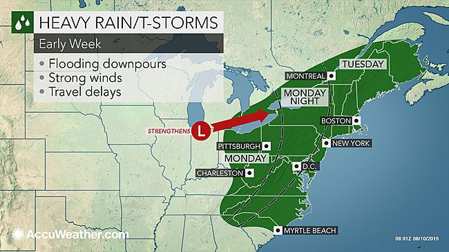
Strong thunderstorms are possible today from Montreal south and east into the Townships, New York and Vermont. (AccuWeather)
A potent cold front will slide southeast across southern Quebec later this morning and this afternoon. The front has a history of generating strong to locally severe thunderstorms along it. On Sunday strong storms swept Michigan and southwest Ontario. Power was knocked out to thousands along with reports of damage including fallen trees and power lines. Hail and heavy rain were also observed. Isolated tornadoes also occurred from Iowa into extreme southwest Ontario. The biggest threat for severe weather across metro Montreal will occur from 11am onward towards sunset. Isolated strong storms will produce gusty winds, heavy rain and hail. A severe thunderstorm watch is in effect this morning for the border regions south and east of Montreal and may be extended later this morning.
A tree crushed this VW on Grace Street in Toronto Sunday afternoon. This was just one of numerous trees and power lines brought down across southwestern Ontario from strong thunderstorms. PHOTO: (Twitter @NEWSneil)
Early this morning scattered showers are occurring along a warm front in Montreal. It is a rather humid morning with current temperatures around 21C (70F) across the region. Highs today will range from 25 to 30C (77-86F) region wide, depending on how much sunshine you get before the cold front arrives. As the front clears the region later tonight, skies will become partly cloudy with lows in the middle teens. More unsettled weather is likely on Tuesday with showers and thunderstorms lingering. Temperatures will trend slightly cooler than normal through the middle part of the week.

Friday 31 July 2015

Do not leave your dog in a car on a hot summer day

The temperature inside my car with the windows drawn reached 56.1C on a hot spring day back in early May. These temperatures can be reached in as little as 15 minutes with your windows closed.
Why do we have to keep reinforcing what seems like a very simple message to irresponsible dog owners who continue to leave their dogs in hot cars while they shop or eat? Again this week, right here on L'Ile Perrot, a woman doing groceries left her small dog in her car on the hottest day of 2015. The temperature rose to 33C (91F) which likely set the temperature in the car well over 45C (115F). The dog was rescued by some good samaritans and the provincial police were called. Her response when she returned 45 minutes later, she had no idea you should not leave your dog in a hot car. Really? This dog would have died. Even on a 25C (77F) day the temperature will rapidly approach the high 30's (100F) inside your car. Thousands of dogs suffer a similar fate each summer across North America.

This dog was rescued from a hot car on the warmest day of 2015 on L'Ile Perrot. (CJAD)
The temperature can rise very fast in a closed car, even with the windows cracked. Within a few minutes the dog will be suffering from the horrible symptoms of heatstroke and dehydration. A dog can suffer brain damage or even death within as little as 20 minutes. Dogs already have a difficult time in the heat as they don't sweat, but cool through their paws and by panting. Leave the dog at home or have another adult remain in the car while you shop. That is what we do with our Bella. There is no excuse. I posted a picture to show you just how hot it can get in your car. Another note regarding pet safety, be mindful of their paws on hot surfaces. Below is a photo of  how hot the pavement was on Wednesday afternoon.

Watch your dog's paws! A little out of focus but you get the point. The temperature on the pavement here on L'Ile Perrot Wednesday afternoon was a sweltering 58C (136F).

Tuesday 28 July 2015

Massive tornado in Manitoba - heat advisory for Montreal

A spectacular shot of Greg Johnson's team tracking a large tornado near Tilston, Manitoba Monday evening. 
(Tornado Hunters)
It was a wild weather night across southern Manitoba on Monday as a strong low pressure area lifted north from the Dakotas into Saskatchewan. The ingredients were perfect for supercell thunderstorms and mother nature did not disappoint. A large wedge shaped tornado with multiple vortices was on the ground for nearly 3 hours according to Environment Canada. The tornado, up to 4km wide at times, was largely in rural areas of southwest Manitoba near Tilston. Storm chasers in the area recorded winds in excess of 120mph (200km/h). They were likely stronger closer to the tornado with pavement being scoured from highways. At first light we will see if more damage has occurred. Hail the size of baseballs also fell in the region along the North Dakota border. Heavy rain on the backside of the storm produced flooding in Saskatchewan including Regina, where more rain fell yesterday (78.2 mm), than in the last three months. Flooding was also reported in my old home town of Gravelbourg, Saskatchewan. More storms are forecast today in Manitoba, with strong winds in Saskatchewan.

Lightning illuminates the sky on L'Ile Perrot last night. (ValleyWeather)
 Meanwhile southern Quebec had a warm and humid day Monday followed by strong thunderstorms last evening. The storms rolled across the Island of Montreal and L'Ile Perrot after 8pm. Heavy rain and frequent lightning occurred, putting on quite a show. I measured 16 mm of rain at my home in less than 30 minutes along with vivid lightning, lasting over one hour. Lightning is extremely dangerous, and this was highlighted last night as a cyclist was struck in the Rosemont district of Montreal. He was listed in critical condition this morning after going into cardiac arrest. The storms also knocked out power to thousands in Quebec. A fire in Brossard was blamed on a lightning strike and there were reports of hail in St Hubert. Numerous trees were knocked down across the Beauce along with flooding. Between 50-100mm of rain fell near the New York State border in Huntingdon.

The warm and humid weather will persist through Thursday with more storms likely each day. A heat advisory is in effect stretching from southern Ontario into southern Quebec. High temperatures at or above 30C along with high humidity, will make it feel more like 40C. Stay hydrated and keep an eye on the sky for late afternoon and evening storms.

Street flooding from Gravelbourg, Saskatchewan after more than 75mm of rainfall Monday. 
(Gravelbourg Fire Department)

Monday 27 July 2015

Warm and humid week for Montreal

More widespread severe weather is forecast for the southern Prairies today and tonight. There is an elevated risk of dangerous storms in southern Saskatchewan and Manitoba today. Above: Strong thunderstorms produced this funnel cloud near Calgary late last week. (CBC News)
An unseasonably strong area of low pressure will move from the northern US plain states into southern Manitoba over the next 48 hours. This storm will push a surge of warm and humid air from eastern Saskatchewan across the Great Lakes and into Quebec this week. Along the path of the storm very strong thunderstorms are likely, with heavy rain, up to 30mm behind the system. There is an elevated risk of large hail and tornadoes across eastern Saskatchewan and southern Manitoba today into tonight. Already this morning watches and warnings are on place across the southern Prairies. Temperatures will soar into the low 30's (low to middle 90's) from Manitoba across southern Ontario and into southwest Quebec this week. Humidex readings will approach 40C (104F) in many locations including Toronto and Montreal.

MONTREAL
For the specifics, we are looking at hazy sunshine in Montreal through Thursday with daytime highs near 30C (86F) and overnight lows near 21C (70F). Areas of fog are reported this morning in the region, and may form each morning this week. Each afternoon into the early evening there is a 40 per cent change of scattered thunderstorms, some may be strong. A cold front will bring more widespread showers and thunderstorms by Thursday. Cooler and dryer weather will return to southern Quebec by next weekend.

Friday 24 July 2015

More showers and storms expected in southern Quebec

Numerous showers and thunderstorms developed in southern Quebec on Wednesday and Thursday including this one near Vaudreuil. The trend will continue today. (ValleyWX)
An upper level low spinning over southern Quebec has maintained a pool of cool and unstable air over the region. Montreal has had very unsettled weather the last 48 hours, with numerous showers and thunderstorms. The trend will continue today with showers and thunderstorms scattered about all day. The clouds and precipitation will help to keep temperatures cooler than normal in the low to perhaps middle 20's. Additional rainfall may be significant is some of the storms, adding to the impressive totals so far this month. Small hail is also possible. I have measured 104.5mm (over 4 inches) of rain here at my home on L'Ile Perrot, 105.9mm has fallen at Sainte-Anne-de-Bellevue with 87.2mm at Trudeau Airport. The clouds and frequent rain has meant a cooler than normal July for the city.

Warmer air will nudge the upper level low northeast and out of Quebec this weekend. (AccuWeather)
Looking ahead, high pressure will briefly clear the skies over Montreal and southern Quebec tonight into Saturday with sunshine forecast, lows of 16C (60F) and highs up to 26C (79F) Saturday. By Sunday the heat and humidity will be on the rise with temperatures climbing into the upper 20's and even low 30's by Tuesday. Numerous showers and thunderstorms will be around Sunday and next week in the warmer more humid air mass.

El Nino
The much talked about El Nino, that ribbon of warmer than normal water in the Pacific Ocean off the South American coast, continues to upset weather patterns across the globe. The current El Nino is showing no signs of leaving anytime soon and may be strengthening. It has led to a very unsettled and at times destructive weather pattern across North America from heavy rain and flooding in California to intense wildfires in northern Saskatchewan. El Nino has also been responsible for an increase in severe weather across central portions of the continent as well as cool weather for Atlantic Canada and Quebec.